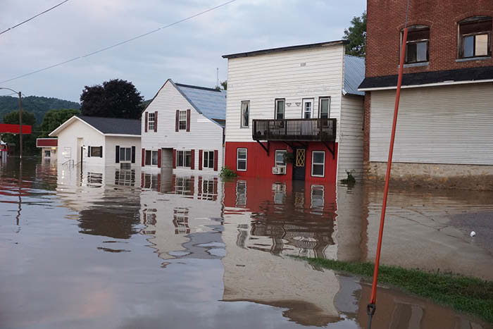
A scene from the August 2018 flood in Ontario (N. Garden St.)
Editor’s note: Kickapoo neighbors face the same issues. But has Ontario’s development made it worse for its residents?
James Twomey of Valley was appointed floodplain zoning administrator for the village of Viola last winter. The article below explains the issues surrounding flood plains. While directed to Viola residents, any town on the Kickapoo easily could be substituted.
By JAMES TWOMEY
Viola floodplain zoning administrator
Viola, like many other communities in Wisconsin, owes part of its prosperity and part of its difficulties to being located near water. In Viola’s life, this is the Kickapoo River. The “bottom land” was incredibly fertile, and its smooth topography meant that railways and roads were easily built. Also, before electric power, water was used to generate power to operate sawmills and gristmills. The Kickapoo River made Viola grow and prosper.
Managing risk in a floodplain became more challenging as communities upstream and downstream grew. Each structure changed the way floodwaters behaved. For a good visual, imagine water coming out of a hose; now imagine your thumb as a few downtown buildings. The same amount of water may be coming out of the hose, but the water is doing weirder, more forceful things and is difficult to predict. The more construction that occurred in the Kickapoo floodplain, the wider and more random the damage became. One communities’ construction caused changes in the motion of floodwaters downstream.
To help property owners cope, the Johnson Administration created a National Flood Insurance program to encourage flood insurance for real estate, which was guaranteed and subsidized by the federal government. If a community wished to participate in this program, it had to adopt a plan of management. These were formalities that many communities never really took seriously. Insurance is pretty boring, after all.
Over time, we have seen an increase in the number of buildings in the floodplain, and an increase in property losses, as well as an increase in levels of rainfall or runoff. The “relaxed” approach to enforcement of the insurance rules became state mandates, and in Wisconsin, this is administered by villages adopting the rules and regulations as written by the DNR. It is important to remember that these are Viola’s rules, and village officials are responsible for their enforcement. They can be stricter than those of the DNR, but cannot be more lenient.
These are reasons why Viola has a floodplain zoning administrator. We live in Wisconsin, and the DNR has jurisdiction in these matters. We are required to be in compliance with DNR’s interpretation of a set of complicated rules and regulations regarding homes and businesses located in the floodplain.
We know why communities developed near the Kickapoo River. But, like all rivers, it can overflow. One senior village resident said that in his lifetime, his house has been flooded nine times. He was born in Viola’s floodplain 90 years ago, and he wishes to live out his remaining days here. Time, and the river, seem to flow faster as we get older.
FEMA and the DNR cooperated to form a map of our village that compares the elevation of the land to the likelihood of water flowing over it or pooling upon it.
In short, these are the low-lying parcels and fields that have been flooded in the past or are likely to be flooded in the future. The lowest area where water moves over the land is called the floodway. Many areas that are slightly higher or farther away from the floodway also tend to have standing water on them during a flood. Those areas are called the flood fringe. Combine these two areas, and that’s the floodplain.
On a warm, sunny day, it is very hard to see where the floodplain begins or ends. Perhaps this invisibility causes us to be surprised when a banker or realtor says you must buy flood insurance. But everyone can see the floodplain from above. Simply go to https://msc.fema.gov/portal/home and enter, for example, “Ontario, Wisconsin.”
The striped areas marked “Regulatory Floodway AE” are at the highest risk of damage due to moving water. The zoning rules are very strict in this area. The blue shaded areas marked “AE and A” are more likely to have pooling or ponding. These zones are estimates and are updated based upon actual damage. Flooding does occur outside of these areas, but insurance rates are lower. The special floodplain zoning rules only apply to zones AE and A.
As our 90-year-old citizen has pointed out, “100-year” floods happen about every 10 years in Viola. It’s an unfortunate phrase because it implies that floods can be predicted or occur in a cycle. The “100-year” flood is actually a complicated legal and statistical phrase based upon engineering math: Qp=CiA. It is designed to establish insurance rates based upon risk of an event equal to or greater than another event. It was never meant to tell us how frequently a house will get flooded. Here is what the math actually says: the Kickapoo River will overflow its banks based upon a combination of how much rain falls and how wide an area the storm covered, minus the amount of water that soaked into the ground.
It is this last part of the equation that can never be predicted. Did someone upstream just clear their hickory stand? Did a farmer plow up alfalfa and plant soybeans? Is the ground already wet from a previous rain? Is the ground frozen? Did a company pave its parking lot? Since there is no information being shared about these issues, the “100-year” flood is a guess based upon assumptions that are always wrong or unknown. History, and our senior citizens, tell us that the Kickapoo will overflow its banks 10 times in a century, and the time between flood events is random. People should purchase flood insurance to deal with this situation: the future is as clear as mud.
Although large parts of Viola are in the Kickapoo River’s floodplain, we have the support of federal, state, and local officials who help to manage the situation. Of course, mistakes get made, and paperwork is a hassle. Most property owners, however, have made significant investments to minimize the risks of future flood damage using FRED’s help.
Who or what is FRED?
In this series, I’ve tried to introduce the community to the increasingly strict interpretations of the DNR’s floodplain rules and regulations. There is an understandable tension between their “returning it to its natural state” and the village’s desire to keep these historic business and residential areas. We’ve learned that life in the floodplain involves a 10 percent risk of a flood event every year. That’s 10 floods per century. This risk is managed by subsidized flood insurance and financial incentives to bring these buildings into compliance.
The compliance rules come in two flavors: “No” and “Yes, but.” When we look at areas in the regulatory floodway, there really is no development allowed. But for those areas in the flood fringe, the long-term goal is to bring the buildings up to FRED rules. F.R.E.D. is the acronym for the choices that the law allows a community to make:
1. Flood-proofing a building’s lower levels
2. Relocating a building to another part of downtown
3. Elevating a building so that its lowest floor is at least 2 feet above the legal definition of the Kickapoo’s flood stage
4. Demolish a building that is at the end of its useful life.
In every flood insurance policy, there is a $30,000 bonus to do one of these things! Also, Wisconsin Emergency Management and the DNR offer grants, matching funds, and low-interest loans to accomplish these goals!
Flood insurance should not be seen as an expense to avoid; rather, it is an investment that is certain to pay a dividend. Flooding will occur along the Kickapoo River, and the policy will pay for one these things. Insurance agents call it the “ICC Rider.”
It is also time to start thinking about what uses these areas in the floodway and flood fringe can be put to: floodways can be parks with pavilions, they can be fish hatcheries, they can be organic orchards leased out to local Amish and the produce sold in a local cooperative. Floodways can be planted with deep-rooted legumes such as alfalfa and Kura clover, the rights to which can be auctioned off.
Parcels where flood-damaged homes have been removed can be auctioned off with the condition that only flood-proof and elevated housing or mixed-use buildings be constructed.
In other words, Viola’s planning, zoning, and administrative leaders need to stop thinking in terms of being victims of flooding. We need to stop complaining about what the DNR says we can’t do, and we need to focus our attention on what we can do.
The single most important message we should convey to the citizens of Viola is that life in the floodplain cannot go on “as usual,” but it can go on in many productive ways: organic agriculture, safe housing, and flood-proof commercial space.
The more time I spend talking to folks in Viola, the more I am convinced that private development entrepreneurs are ready and willing to do this. I see a Viola with a revitalized downtown business district. I see a Viola with new housing in the downtown area. I see a Viola with a grocery store, a pharmacy, a coffee shop, and a population of 1,200. Village officials need to get these parcels back into the hands of responsible stewards of the land and compassionate landlords. Viola’s downtown can be engineered to be compatible with the increased rainfall of this 21st century.